The Unexpected: In the time of Louis XII's heir

Good chapter, looking forward to Spanish and French war and that France will finally be able to make good conquests in the Low Countries

Considering I'm thinking upon the period immediately following this TL, I'm working on the build-up of this conflict due to the context and its specificities.
 
Appendices: Portraits
Portrait of Charles IX of France (1515-1569)

Charles IX de France.png.jpg


Portrait of the young Elisabeth Jagellon, Princess of Poland and Queen of France (1520-1579)
Princesse Elisabeth Jagellon.png.jpg


Portrait of Prince Charles of France, future King Charles X of France (1538-1588)
Prince Charles de France.png.jpg
 
Appendices: Period maps (Christendom)
Christendom in July 1515

Europe 1515.gif


Christendom in January 1530
Europe 1530.gif


Christendom in January 1545
Europe 1545.gif


Christendom in January 1570
Europe 1570.gif


Notes:
1- The blue star symbolizes the Union of Kalmar.
2- The dark violet star represents the domains controlled by Charles V.
3- The light purple star represents the domains controlled by Ferdinand of Austria during his brother's reign.
4- The thick black border line represents the limits of the Holy Roman Empire.
5- Territories in white are unexplored/uncontrolled.
6- Hatched areas represent disputed territories.​
 

Attachments

  • Europe 1570.gif
    Europe 1570.gif
    108.6 KB · Views: 30
Appendices: Period maps (Mediterranean Sea)

Appendices: Period maps (Mediterranean Sea)

The Mediterranean in July 1515
Méditerranée 1515.jpg


The Mediterranean in January 1530
Méditerranée 1530.jpg


The Mediterranean in January 1545
Méditerranée 1545.jpg


The Mediterranean in January 1570
Méditerranée 1570.jpg
 
A little question: maps are what composed the remaining appendices before a final announcement.

As the French version is now totally published, I have two possibilities:
_ either keep the current pace
_ or double publications

In the first case, it is for six months of publication.
On the second, for three months.

I have no issue to take one or the other, but I'd like to have your opinion.
 
Appendices: Period maps (Middle East)
Middle East in July 1515
Moyen-Orient1515.jpg

Middle East in January 1530
Moyen-Orient1530.jpg

Middle East in January 1545
Moyen-Orient1545.jpg

Middle East in January 1570
Moyen-Orient1570.jpg
 
Appendices: Period maps (New World)
Major French expeditions to the New World (1524-1537)

1. Giovanni da Verrazzano's expedition (1523-1524)
Expédition de Verrazanno (1523-1524).jpg


2. Giovanni da Verrazzano expedition (1525-1527)
Expédition de Verrazanno (1525-1527).jpg


3. Giovanni da Verrazzano expedition (1528-1531)
Expédition de Verrazanno (1528-1531).jpg


4. Giovanni da Verrazzano and Jacques Cartier expedition (1532-1533)
Expédition de Verrazanno et de Cartier (1532-1533).jpg


5. Giovanni da Verrazzano and Jacques Cartier expedition (1534-1537)
Expédition de Verrazanno et de Cartier (1534-1537).jpg


Legend:
1. Thick line: main expedition
2. Thin line: local explorations (except for expedition 3. Jacques Cartier's expedition to determine the location of Fort Charlesbourg)
3. Circled dot: founding of a colony

Territories of New France and French exploration in 1570
Situation de la Nouvelle-France en 1570.jpg


Legend:
1. Dark blue area: territory controlled by the French in 1570
2. Light blue zone: territory explored by the French in 1570
3. Red stars: French colonies (1: Fort Charlesbourg, 2: Saint-Jean, 3: Fort Sainte-Croix, 4: Fort Valois)​
 
Appendices: Map of denominational distribution in Christendom at the dawn of the 1570s

Répartition confessionnelle en 1570 UTL en Europe.gif


Legend:
1-Dark magenta: predominantly Catholic region
2-Dark magenta star: large Catholic community
2-Flesh pink: region with a strong Lutheran presence (and/or under the authority of Catholic rulers)
3-Cardinal red: Lutheran-majority region
4-Cardinal red star: large Lutheran community
5-Red ochre: large Calvinist community
6-Crimson red: predominantly Calvinist region
7-Crimson red star: large Calvinist community
8-Red star: large Tyndalian community
9-Sky blue: predominantly Orthodox region
10-Sky blue star: large Orthodox community
11-Cyan green: region with strong Christian presence (under Muslim rulers)
12-Green: region with Muslim majority​
 
Delay Warning
Delay Warning

From thursday till May 5th, I'll be in vacation in Italy with my family, and unable to publish the next appendice for the next week.

I didn't inform before because I wasn't sure if I'll bring my PC for this endeavour and I finally decided otherwise, notably to benefit of time with my family and rediscover Toscany again.

Once I'm back, this message might be deleted as it is a temporary measure.
 
Appendices: Maps (Holy League War, 1523-1527)
Soliman's campaigns (1521-1523)
Campagnes de Soliman (1521-1523).jpg


Legend:
_ Dark green line: Soliman campaign of 1521
Apple green line: Soliman's campaign of 1522-1523
Red star: Ottoman success (1: Capture of Belgrade)
Black star: Ottoman defeat (2: Siege of Rhodes)

Holy League War (Balkans, 1524-early 1525)
Guerre de la Sainte-Ligue (Balkans, 1524).jpg


Legend:
_ Blue line: movement of French troops led by François d'Angoulême (François III of Brittany)
_ Violet line: movement of Hasbourg and Hungarian troops
_ Red star: victory of the Holy League (1: Capture of Durrës, 2: Capture of Belgrade)

Holy League War (Balkans, 1525)
Guerre de la Sainte-Ligue (Balkans, 1525).jpg


Legend:
_ Dark green line: Soliman's campaign of 1525
_ Violet line: movement of Holy League troops
_ Black stars: defeats of the Holy League
_ Green dotted circle: siege in progress
_ Clashes: 1-Hisarlik , 2-Capture of Belgrade, 3-Siege of Durres

Holy League War (Balkans, 1526)
Guerre de la Sainte-Ligue (Balkans, 1526).jpg


Legend:
_ Purple line: Holy League campaign of 1526
Black star: defeat (of the Holy League)
_ Confrontation: 1-Siege of Belgrade

Holy League War (Mediterranean, 1524-1526)
Guerre de la Sainte-Ligue (Méditerranée, 1524-1526).jpg


Legend:
_ Brown line: English fleet movement
_ Violet pink line: Anglo-Portuguese fleet movement
_ Burgundy line: Spanish fleet movement
_ Orange line: movement of the Holy League fleet in autumn 1524
_ Yellow line: movement of the Holy League fleet in 1525
_ Dark brown line: Egyptian campaign of 1525
_ "Ochre" line: movement of Holy League forces (Charles V) in 1526
_ Bright orange line: outline of territory "liberated" by the Holy League from Ottoman tutelage
_ Red star: victory of the Holy League (1: Capture of Algiers, 2: Capture of Damietta, 3: Capture of Cairo, 4: Battle of El-Qantara)​
 
Appendices: Maps (War of the Two Kings, 1529-1537) New
Appendices: Maps (War of the Two Kings, 1529-1537)
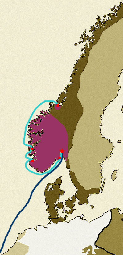
War of the Two Kings (Christian II expedition, 1529)
L'Inattendu : à l'époque de l'héritier de Louis XII - Page 13 Guerre14

Legend:
1- Dark blue line: Christian II expedition in summer 1529
2- Red star: Christian II's success (Oslo rally)
3- Cyan blue line: Soren Norby and Klemen Andersen's expedition to rally the other major cities of the Kingdom of Norway (autumn 1529)
4- Red squares: cities rallied to Christian II
5- Dark purple territory: territory rallied or controlled by Christian II

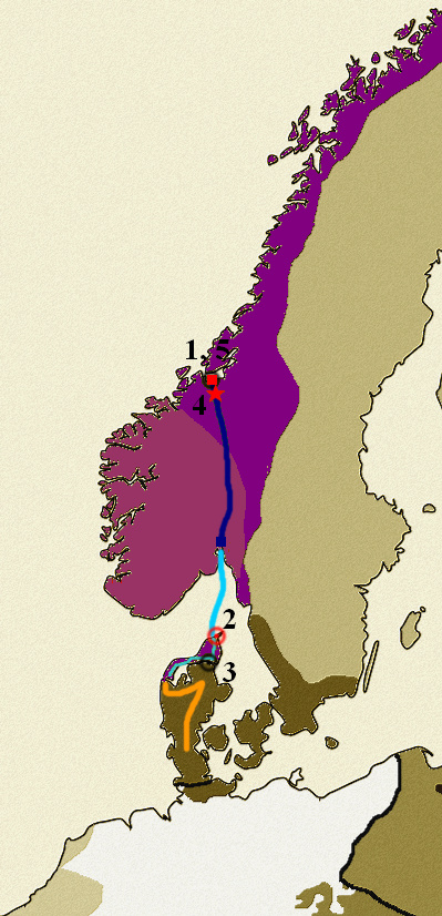
War of the Two Kings (1530)
L'Inattendu : à l'époque de l'héritier de Louis XII - Page 13 Guerre15

Legend:
1- Cyan blue line: Klemen Andersen's expedition to rally Vendyssel and Jutland to Christian II's cause
2- Dark blue line: expedition by Christian II's forces to retake Trondheim (summer 1530)
3- Light orange line: John Rantzau's campaign towards Vendyssel
4- Red star: success of Christian II's allies (4: Battle of Lundamo)
5- Red square: recapture of Trondheim (5)
6- Red dot circle: capture of Skagen (2)
7- Circle with black dot: capture of Tronheim by Vincens Lunge (1) and failure of Aalborg (3)
8- Burgundy purple territory: territory controlled by Christian II in early 1530.
9- Dark purple territory: territory rallied or captured by Christian II's allies at the end of 1530.

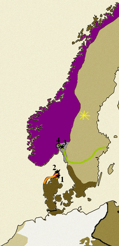
War of the Two Kings (1531)
L'Inattendu : à l'époque de l'héritier de Louis XII - Page 13 Guerre16

Legend:
1- Light orange line: John Rantzau's campaign to retake the Vendyssel
2- Apple-green line: Gustav I Vasa's campaign against Christian II
3- Black star: Danish-Norwegian defeat (1: Battle of Wra, 2: Loss of Skagen 3: Battle of Sarpsborg)
4- Black dot circle: loss of Oslo (4)
5- Yellow spark: Bell revolt in Dalarna against Gustav I
6- Dark purple territory : territory controlled by Christian II
7- Gray territory : territory captured by the Swedes

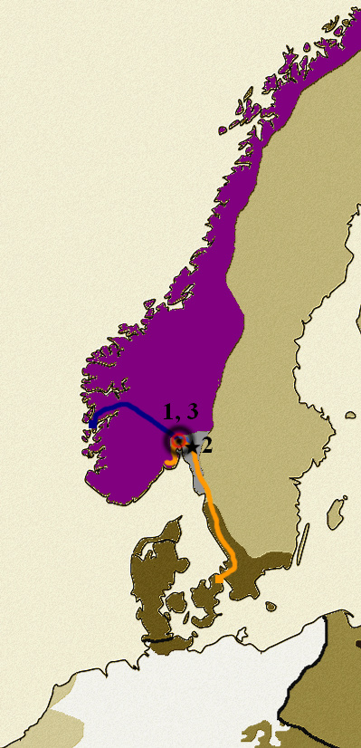
War of the Two Kings (1532)
L'Inattendu : à l'époque de l'héritier de Louis XII - Page 13 Guerre17

Legend:
1-Dark blue line: Christian II's campaign in early 1532
2- Light orange line: Mogens Gøye's campaign in summer and autumn 1532
3- Circle with red dot: recapture of Oslo (1)
4- Black star: Christian II's defeat at Ytterbygda (2)
5- Black dot circle: loss of Oslo (3)


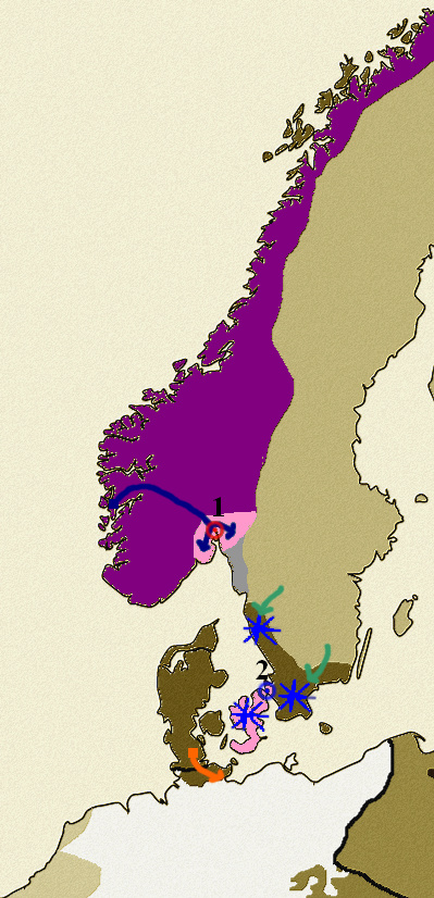
War of the Two Kings (1534)
L'Inattendu : à l'époque de l'héritier de Louis XII - Page 13 Guerre18

Legend:
1- Dark blue line: Christian II's campaign
2- Light orange arrow: Christian III's campaign against Lübeck
3- Cyan green arrows: Swedish raids
4- Red-dotted circle: recapture of Oslo (1)
5- Blue-dotted circle: siege of Helsinborg (2)
6- Blue spark: pro-Christian II revolt
7- Pink territory: territory retaken by Christian II or occupied by pro-Christian II rebels

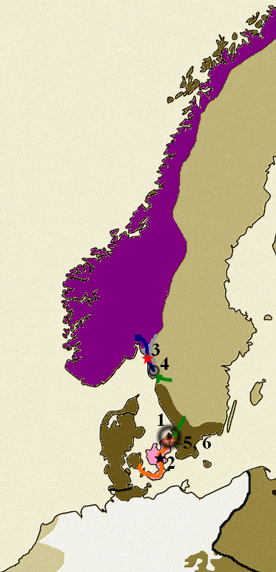
War of the Two Kings (1535)
L'Inattendu : à l'époque de l'héritier de Louis XII - Page 13 Guerre19

Legend:
1- Dark green arrows: Swedish attacks
2- Dark blue line: Christian II's campaign against Bohuslan
3- Light orange line: John Rantzau's campaign in Fionie
4- Red star: Christian II's victory at the Battle of Uppsala (3)
5- Black star: John Rantzau's victory at the battle of Øksnebjerg (2)
6- Black dot circle: Loss of Helsinborg (1) and failure to capture the fortress of Bohus (4)
7- Orange-dotted circle: sieges of Copenhagen and Malmö (5 and 6) (since the two cities are almost opposite each other, the circle counts as two).

War of the Two Kings (1536)
L'Inattendu : à l'époque de l'héritier de Louis XII - Page 13 Guerre20

Legend:

1- Dark blue line: naval support expeditions to Malmö and Copenhagen by Klemen Andersen
2- Cyan blue line: Dutch fleet and Søren Norby's expedition to support Copenhagen and Malmö
3- Circle with black dot: capitulations of Malmö and Copenhagen in winter 1536
 
Top